 |
|
|||||||||||
THE CİSTERN AND AQUEDUCT OF CERAMAOS IN ANCIENT CARIA*Mehmet BildiriciLocation of CeramosOne of the ancient Carian cities, Ceramos, now Ören is on the north shore of the Ceramic Gulf (modern Gökova Gulf). It is 40 km from Milas (ancient Mylasa) and 60 km from Bodrum (ancient Halicarnassos). Milas is now the administration centre for Ören. The ancient site of Ceramos is located at the steep foot of Kocadağ Mountain with fertile alluvial plain between the city and the Gulf of Ceramos. The population of Ören averages 5000 in the winter and swelling to 30 000 in the summer The NameThe name of Ceramos means the "pottery" in Greek. The city's name was passed on the adjacent gulf as the "Ceramic Gulf". Today the new Turkish name for the gulf is the "Gökova Körfezi". The ancient name Ceramos survives as "Gereme" today. The modern city's name Ören means ruins in Turkish. History of CeramosLittle of the city's history is known during the archaic era between the 7th and 6th centuries BC. In 546 BC the Persian army under the command of Harpagos conquered all of Caria. Under the Persian rule the customs and the religion of the conquered area remained unchanged. In the 5th century BC Ceramos was a member of the "Delos Sea Federation" (Delian League) under the leadership of Athens and paid 1,5 talents every year. The Delian League ended in 405 BC. Between 387-334 BC, the Persians once again took the control of Caria. King Mausolos (reigned 377-353 BC) maintained good relations with Persian King and governed the region as an autonomous king. He changed the capital from Mylasa to Halicarnassos (modern Bodrum). Greek language and civilization penetrated Caria. Ceramos was one of the important cities in his kingdom. This period ended when Alexander the Great (356-323 BC) of Macedonia invaded the region. The area had difficult time from 334 up to 189 BC when the Peace Agreement of Apameia was reached. At this time Ceramos came under the control of Rhodes. Finally in the first century BC, the city became part of the Roman Empire. During the Roman era the city flourished. Many of the monuments we see today came from this period (1). The early Byzantine period Ceramos was the centre of Christian Episcopacy. Then the city disappears in history. Monuments of CeramosThere have been no serious archaeological surveys or excavations of the ancient site. The modern town of Ören was built upon the historical site. In many cases the actual ancient walls were used for the walls of the modern houses. The ruins of two temples, city walls, baths, churches, rock cut tombs, aqueduct, and cisterns can be seen today (2) Kurşunlu YapıThe ruins of the first temple are called "Kurşunlu Yapı" which means in Turkish "leaded construction". Only the platform of the temple can be seen today. Who the temple was dedicated to is unknown. It was converted to a church in the early Byzantine period (Fig 2,2). *.Mehmet Bildirici, İnşaat Yüksek Mühendisi, P.K 42 Mecidiyeköy-İstanbul 1.Bildirici, M, 2002, “From Idyma to Gökova-Akyaka: www.akyaka.org/akyaka/idima/idima_eng.htm 2.Ören Turizm Tanıtmave Sağlık Vakfı, 2002, Ören (Ceramos) The ruins of the second temple are on Bakacak Hill (Fig.2,1).
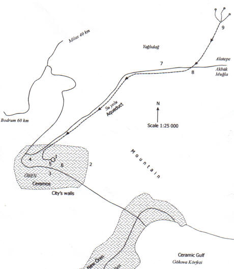
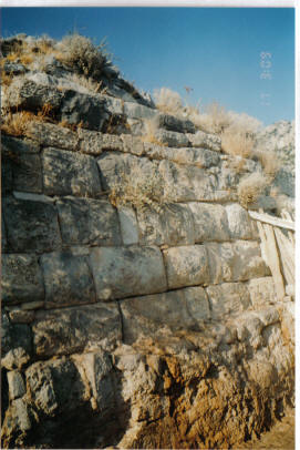
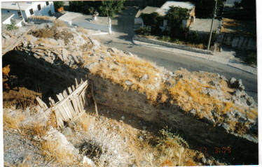
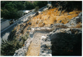
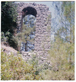
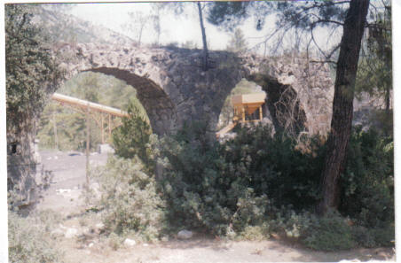
AQUEDUCTFive springs are located to the north of the ancient city (Fig2,9) provided water to the aqueduct that served Ceramos (Fig.2). These are as follows: 1.Ali Cin, 2. Gürlek, 3.Suçıkan (Now this spring feeds modern Ören), 4. Olucak, 5. Zait Pınar The route of the aqueduct is shown on the map (Fig.2, 7) provided by Mustafa İskender who is engineer in Ören Belediyesi and Hüsamettin Aktaş who is ex Vice Mayor of Ören. The arches of aqueduct arcades can still be seen along the right side Alatepe village road. Alatepe village is on the road to provincial centre of Muğla. In the photograph four spans of the aqueduct along Alatepe road can be seen as well as another aqueduct arcade in the deep valley. Water-Tanks and CisternThe aqueduct fed water-tanks and a cistern on the Bakacak Hill (Fig.2,1). Earlier a temple was constructed on Bakacak Hill. The supporting wall of the earlier temple was used for the cistern construction. Today only the supporting wall and some fragments of the temple remain. The water channel (Fig.3, C) that is supplied by the aqueduct was lined with hydraulic plaster (P.3). The width and the height of the channel are 30 cm and 25 cm. The cistern tanks (Fig.3,A) now filled with rubbish and brush. Three of four chambers in the bottom of the tanks were probably constructed for silting process. There are two possibilities in the cistern operating: a) The water tanks (A) were fed by the aqueduct at the bottom of the tanks, water rose and poured into the channel C, and overflows to Cistern (Fig.3, B) after settling and silting process. b) The water-tanks A was fed by the channel C, after settling and silting process flows to the cistern (Fig.3, B). CISTERNThe cistern is shown in the photograph The height of water: 1,50 m, The volume of the cistern: 4,5 m x 1,5 m x 21 m = 142 m3 No hydraulic plaster was found on the bottom and on the walls of the cistern. The wall facing the mountain utilizes the supporting wall of what is probably the temple on Bakacak Hill. This supporting wall was constructed of very regular yellowish limestone blocks. The remaining walls of the cistern were than constructed using rubble fill. Good engineering skills were demonstrated in the construction of the buttress walls facing the city. Buttress arches on outside were constructed to off set the horizontal force of the water in the most economic manner. In the front elevation the buttresses can be identified. The height of the buttress on the corner is approximately 10 meters due to the slope of the ground. The remains of a bath can be seen in the foot of Bakacak Hill. Vent pipes for the hypocaust system are visible in the upper walls.
The Date of the Aqueduct and the CisternThe aqueduct and the temple on Bakacak Hill were built earlier than the cistern, probably in the Roman era. Based on the type of construction, the cistern was probably built in the early Byzantine period. CONCLUSIONCeramos was very important and prosperous city in the Roman era. Houses and commercial buildings of the modern city of Ören now stand on top of the ancient city. New archaeological surveys and the excavation are needed to reveal more of the water system.
|
||||||||||||